iRIC GUI source code abstract
This page describes very basic abstract of the iRIC GUI source code.
Programs and libraries used in iRIC GUI development
iRIC depends on many programs and libraries. Table 1 shows the list of programs and libraries used in iRIC development.
| Program / library | Description |
| Visual Studio 2013 | C/C++ Compiler, Development IDE |
| Qt 5.5 | Cross-platform GUI Toolkit |
| VTK 6.1 | Visualization library (Countour, streamline etc) |
| Qwt 6.1 | Chart drawing library, built on Qt |
| CGNS library 3.2 | CGNS file I/O library |
| Proj 4.8 | Cartographic projections library (Longitude-latitude <-> X-Y) |
| GDAL 1.11 | Raster GIS Data I/O library |
| GEOS 3.4 | Geometry handling library |
| Shapelib 1.3 | ESRI Shape file I/O library |
| iRIClib | Wrapper library for CGNS library |
| HDF5 1.8 | HDF5 file I/O library. CGNS files are now HDF5, so we need this. |
| NetCDF 4.3 | NetCDF file I/O library. iRIC can import NetCDF files now. |
| yaml-cpp 0.5 | YAML file I/O library |
| FFMPEG | Movie encoder |
| Zip / unzip | Program for zipping and unzipping ZIP files |
| Qt Installer Framework 2.0 | Tool to build iRIC offline installer and online update repository |
The folders of iRIC GUI source code
The major folders that exist in iRIC GUI source code are described in Figure 1.
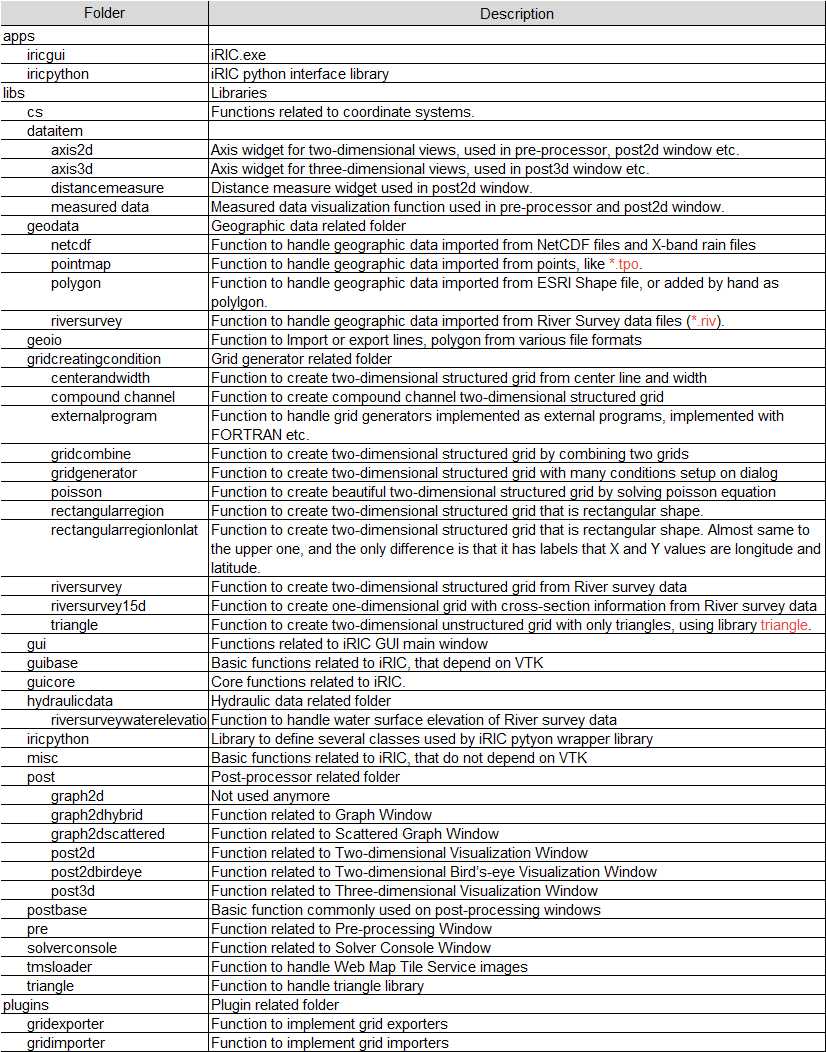
Figure 1 Major folders of iRIC GUI source code
Important classes and methods
The major classes that are inherited by many subclasses are described in Table 2.
| Class | Description |
| ProjectDataItem | Abstract class that hold some data in the project |
| GraphicsWindowDataItem | Subclass of ProjectDataItem. It corresponds to a node in the object browser. |
| GraphicsWindowDataModel | Abstract class that is used as a main interface for data contained in a subwindow |
| GraphicsWindowRootDataItem | Abstract class that is used as a root data container for a subwindow |
| VTKGraphicsView | Abstract class to implement draw region with VTK rendering. Subclass of QVTKWidget. |
| GeoData | Abstract class to implement geographic data. |
| GeoDataMapper | Abstract class to implementing mapping geographic data onto grid nodes or cells. |
| GridCreatingCondition | Abstract class to implement grid creating algorithm. |
| SolverDefinitionNode | Abstract class to implement container for a node inside the solver definition file. |
| Grid | Abstract class to store grid. Used in Pre-processor. |
| PostDataContainer | Abstract class to implement a container for calculation result data in CGNS files. |